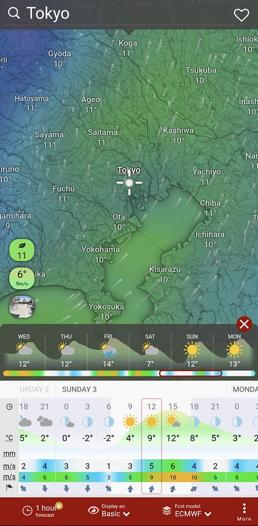
In early February, I ran the course of the “Tokyo Marathon 2024” as a trial run.
I will summarize the features of the course and points to note, including a reminder to myself.
Summary
Access
- It takes about 10 minutes on foot from the nearest station to each entrance gate (Gate 1-5) at the starting point
- To get to Gate 1, I personally recommend the West Exit (West Ticket) of JR Shinjuku Station.
Course Strategy Points
- I recommend lining up on the right side at the start. After the start, the road is narrow, so be careful not to collide with other runners.
- The course is downhill until 6km, so be aware of pace distribution.
- Keep in mind that there are 4 bridge crossings and small ups and downs, so be sure to have enough energy left over.
- Kayaba Bridge (medium up and down) at 14 and 31km
- Kuramae Bridge (the largest bridge on the course) at 20 and 28km
- 10 ups and downs in the 21-27km section (small to medium ups and downs)
- 38-41km may be a headwind section
- Marunouchi Naka-dori Avenue is cobblestone paved, so be careful not to slip!
Course Outline
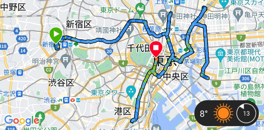
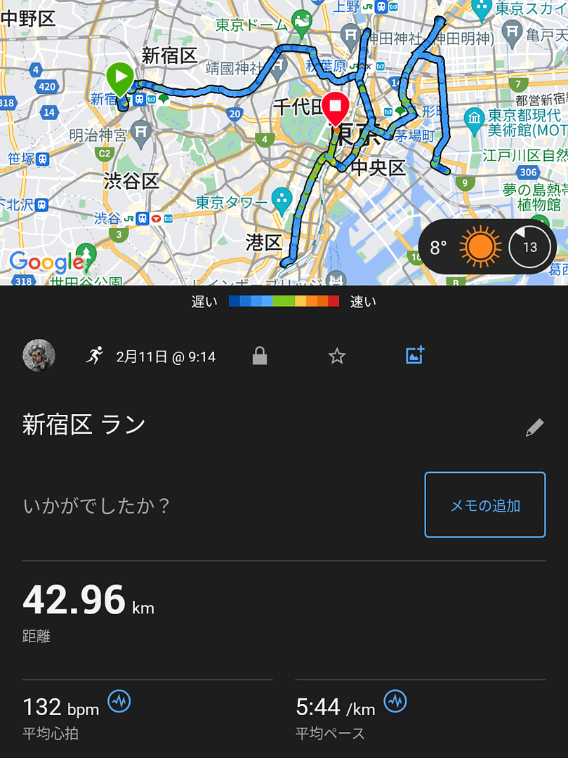
Overall view of the course
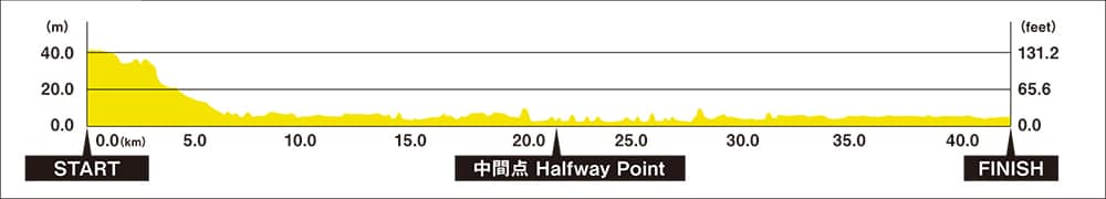
The course starts in front of the Tokyo Metropolitan Government Building, passes through major sightseeing spots in Tokyo such as Akihabara, Ueno, Asakusa, Nihonbashi, and Ginza, and finishes at Tokyo Station. The entire course is relatively flat with a height difference of approximately 40m, making it possible to aim for a good time. That being said, after a trial run, I thought there were a few things to keep in mind. (see below for contents)
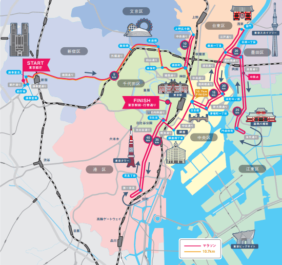
Access to the starting point
Each of the starting point entry gates (Gate1-5) is about a 10-minute walk from the nearest station.
To get to Gate 1, I found the West ticket gate (not the Central West ticket gate) of JR Shinjuku Station to be the easiest way to get to the gate as it is a single-street access.
For reference, the main nearest stations and exits to each Gate are listed below.
| Gate | nearest stations and exits |
| 1 | JR “Shinjuku” Station West Exit *West Ticket gate or Marunouchi Line “Nishi-Shinjuku Station” Exit 2 |
| 2 | Shinjuku Station (Toei Shinjuku Line, Keio New Line) Exit 7 |
| 3 | Exit 7 or Exit 3 of Shinjuku Station on the Toei Shinjuku Line and Keio New Line *Through the One-Day Street underground passage |
| 4 | Toei Shinjuku Line and Keio New Line “Shinjuku Station” Shintoshin Exit |
| 5 | Toei Shinjuku Line and Keio New Line “Shinjuku Station” Shintoshin Exit |
Course Details
This section focuses on the features of the course (ups and downs, strong wind points, etc.) and points to note as felt during the trial run.
Please check the official website for water supply points, sightseeing spots, etc.
Start (Tokyo Metropolitan Government Building) – 6km (Iidabashi)
Immediately after the start, you must turn left twice and turn right.If you want to run smoothly, you may want to line up on the right side at the start.Even in a normal race, there will be congestion after the start, but the road in front of the Tokyo Metropolitan Government Building is narrow, so please be extra careful not to fall over or make contact with others.
After that, there is a small uphill around 3km, but it is basically downhill until Iidabashi. In particular, there is a big downhill after 4km. If you are faster than your expected pace here, you will not have any legs left over in the latter half of the race, so you will want to run calmly.
In addition, this year, there is a new rule to prevent the runners from taking off their clothes before the start, which was a problem last year (?). As a countermeasure against taking off your clothes before the start, there is a “clothing collection box” at the start point, so please use it if you want to take off your clothes and run. I, too, plan to keep warm until the start and use the box.
~14km(Kayabacho)
A little after 14km, a little big up and down at Kayaba bridge. Other than that, the course is basically flat. You want to run mindlessly, thinking of it as an uphill run.
~20km(Near Kuramae Bridge)
The Kuramae Bridge, the course’s biggest up-and-down around the 20km mark (passed again around 28km). Other than that, the course is basically flat. It is still early in the race, so we want to run calmly.
21km~27km(Round trip between Kiyosumi-Shirakawa⇔Monzen-Nakacho)
It was basically flat, but there were 10 small ups and downs in a round trip with a turnaround at 24 km.
Although not as large as the Kuramae Bridge, the ups and downs give the impression of being modest and likely to cut into one’s legs.
~28km(Near Kuramae Bridge(again))
I’m home, Kuramae-bashi.
If you are aiming for time, you want to leave some extra energy at this point. In fact, this is where the race will begin.
~34km(Hibiya)
The course is basically flat, but there is a Kayaba Bridge around 31km.
The race will be exciting as it passes through Nihonbashi, Ginza, and other central Tokyo locations.
34km~37.5km(Hibiya→Tamachi)
Although it is not conspicuous on the official elevation map, I have the impression that there is a steady uphill climb.
(It may be an illusion caused by fatigue after running more than 30 km lol)
This is a heartbreaking point because you pass the goal point once and return about 4 km each way.It would be great if I could run this section with the most energy.
37.5km~41km(Tamachi→Hibiya)
It was a section with a strong headwind. Even though I couldn’t feel it as a tailwind on the outward journey,
However, it is slightly downhill, so let’s try our best to make the last effort.
~Goal(Tokyo station)
Turn left at the Hibiya intersection, then turn right onto Marunouchi Naka-dori Avenue and plunge in.
There is still about 1 km to go to the goal, so this is your last effort.
Most of the streets are cobblestone pavement, so it may be difficult to run. If it rains, it may be slippery, so be careful.